Barnegat Bay Environment

Subwatersheds

Introduction

The Barnegat Bay watershed is the area of land making up the Bay’s drainage system covers over 600 square miles.
The watershed’s characteristics vary from coastal dunes and marshes to other developed lands, to protected Pine Barrens habitats within the Pinelands
Over 560,000 people reside within the Barnegat Bay watershed, which includes nearly all of Ocean County and portions of Monmouth County.

Fun Fact – The Barnegat Bay watershed is comprised of 11 subwatersheds and the barrier island communities.

Barnegat Bay watershed  Subwatersheds    Listed below are 11

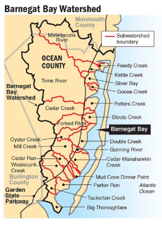
List of Barnegat Bay subwatersheds  

  • Metedconk River
  • Kettle Creek/Reedy Creek
  • Silver Bay/Goose Creek
  • Toms River
  • Potter Creek
  • Cedar Creek
  • Forked River
  • Stouts Creek
  • Oyster Creek
  • Mill Creek/Westecunk Creek
  • Tuckerton Creek

Metedeconk River Subwatershed  90 square miles
This subwatershed  drains into the northern bay with diverse habitats that include forested woodlands, freshwater, forested wetlands, salt marshes, and tidal wetlands.

Kettle Creek Subwatershed (includes Reedy Creek) approximately 950 acres of land
comprised mainly of tidal salt marshes. This area also contains some upland forest, lowland forest, pine barrens/pinelands, cedar swamps, and tidal wetlands.

Silver Bay Subwatershed (includes Goose Creek)
Highly developed with residential housing and commercial use, only a small portion drains into Barnegat Bay Watershed. Habitat include tidal wetlands, marshland, backwater bays and lagoons.  Cattus Island County Park is within this subwatershed. 

Toms River Subwatershed  124 square miles
The Toms River is  feed by dozens of tributaries both large abs small. and flows into Barnegat Bay 11 miles north of Barnegat Inlet.
Much of the headwaters of the Toms River is in the New Jersey Pine Barrens.

Cedar Creek Subwatershed  54.3 square miles.
This subwatershed lies almost entirely within the Pinelands National Reserve. 
There is a dam on Cedar Creek at Route 9 that creates a demarcation between fresh and salt water.
Habitats are, typical to the Pine Barrens, include Atlantic white cedar swamps, bogs (including cranberry bogs), pine and oak forests, and coastal salt marshes.

Potters Creek Subwatershed  Located east of the Garden State Parkway and is mostly within Berkeley Township and a portion of Ocean Gate. 
This subwatershed has residential and lagoon development, protected land, county parks, tidal wetlands and marshes.

Forked River Subwatershed
A large portion of this subwatershed (west of the Garden State Parkway) is in the New Jersey Pinelands and is undeveloped. East of the parkway is highly developed and has a  shoreline on the Barnegat Bay estuary.
Within the subwatershed are the “Forked River Mountains”, two gravelly hills that rise 187 feet above sea level.

Stouts Creek Subwatershed (includes Wrangle Creek)
The immediate area surrounding the Stouts Creek is undeveloped, but  lagoon developments  have disturbed significant portions of this subwatershed.
The undeveloped areas of the Stouts Creek subwatershed habitat are upland forest and salt marsh habitats.

Oyster Creek Subwatershed (includes Double Creek and Waretown Creek)
Much of the land in this subwatershed is either part of the Pinelands National Reserve, managed by the State of New Jersey, or Ocean County.
Habitats, include upland forest, Atlantic White Cedar and maple gum swamps, freshwater bogs, freshwater creeks and lakes, tidal saltmarsh and martime forest

Mill Creek/Westecunk Creek Subwatershed
The Mill Creek and the Westecunk Creek are grouped hydrologically into one subwatershed that also includes Cedar Manahawkin Creek, Cedar Run, Dinner Point, and Mud Cove.

Tuckerton Creek Subwatershed (includes Parker Run)
Originating in the PineLands, habitats include upland pine and and oak forests, salt water tidal marsh, fresh open water, wetland areas including Atlantic white cedar swamps, and sandy beaches.
The Tuckerton Creek is surrounded by extensive coastal wetlands and various residential developments.

Barrier Islands
The barrier islands of the Barengat Bay watershed are almost entirely developed and contribute stormwater runoff directly to the bay. They are not located within the subwatershed of any landward stream.

Credits
Subwatershed Barnegat Bay Partnership